


exp_20 nov. 2016 14-08-26.gpx

CANON2
User
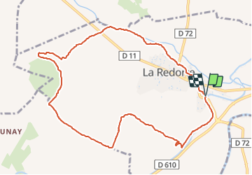

Length
11.3 km

Max alt
110 m

Uphill gradient
117 m
Km-Effort
12.9 km

Min alt
52 m

Downhill gradient
117 m
Boucle
Yes
Creation date :
2022-01-18 08:23:17.973
Updated on :
2022-01-18 08:24:47.098
2h55
Difficulty : Easy

FREE GPS app for hiking
 SityTrail
IGN / Geographical institutes
SityTrail Plus
The world is yours!
About
Trail On foot of 11.3 km to be discovered at Occitania, Aude, La Redorte. This trail is proposed by CANON2.
Positioning
Country:
France
Region :
Occitania
Department/Province :
Aude
Municipality :
La Redorte
Location:
Unknown
Start:(Dec)
Start:(UTM)
472328 ; 4788416 (31T) N.
Comments